Sunday, June 22, 2014

Yin and Yang

Total walking miles last week (6/16 through 6/20): 61.3 miles
Total training miles this weekend (6/21 - 6/22): 30.1 miles


Yin and Yang.
The dictionary describes yin-yang as two complementary forces making up all aspects & phenomena of life. Examples include light and dark. Without light, there can be no dark. They complement one another. As the sun rises in the east, one side of the mountain is filled in light; the other side is hidden in shadow. But as the day progresses, they slowly switch; one now in the light, the other now in darkness.

As I consider my adventure on the Pacific Crest Trail, I keep thinking about the lessons I will have to learn. 
This weekend, as Patti and I walked the trails around Lake Sawyer, I was thinking about how I approach life. 

I am very goal oriented. 
I like to have a plan. 
I like to follow the plan.
I have an image in my mind about what something should be; not necessarily what it is, or what COULD be.

I am afraid that I will be so concerned about the goal, that I will miss the journey.

Will I skip going off trail because it wasn't a part of the plan?
Will I push ahead to "hike my own hike" when others invite me to join them, even though it means not making the miles I had planned? 

Will I slow down enough to enjoy the wilderness; will I let it seep into my soul?

Do I have patience enough to wait? 
     To wait for the stream when the water is too high?
     To wait in the shade when the sun is too hot? 
     To stay an extra day when the weather is too severe?
     To listen to my body when I want to push on?

These types of decisions scare me. 

Light and dark; Earth and sky - Our shadows in the morning sunlight

Trees reach for the light; roots grow down in the darkness - Sunlight filters through the forest.

The mountain and the valley. One of my favorite places to be on a sunny morning.


On Sunday, Debbie and I walked the Mud Mountain Dam "rim trail".
We arrived before the park was open, so we parked outside the gate and made our way to the trail.

Debbie with a full pack. 
 We walked down the "river trail" to enjoy a wonderful view of the White River.
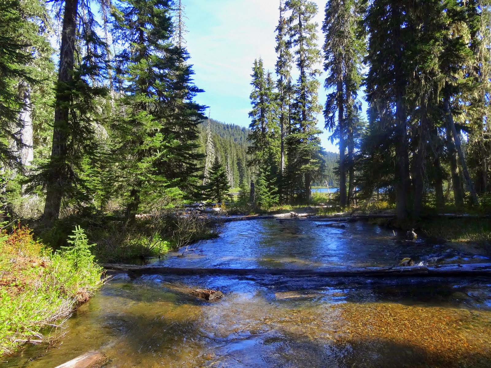
White River near Mud Mountain dam. 
We even walked another portion of the rim trail that I had not walked before. It was fun and we got to see a young deer in the clearing; and a hawk sprang from its perch and soared over the trees. 
Old is replaced by new. A young deer in the clearing.

We got back to the car after hiking just over two hours.

On the way home, Debbie showed me a new way to go. 
A back road. 
A new way. 
It wasn't part of the plan, but it was good.

Yin-yang. It all comes together.

Sunday, June 15, 2014

Building Momentum

Total Miles walked today (6/15): about 15.2

The walking buddies are back together again! Hip, hip, hooray!
It has been a long time since all three of us walked together, and it felt good.
I love hearing all of the conversation again, and the stories, and funny comments about life.

It put a smile on my face and a bounce in my stride.

Patti had on her new hiking boots, and everyone arrived with full packs, all their gear and a lot of enthusiasm. If someone was watching us, I suspect they'd think we were out for a long trip into the back country!

Debbie told us about a hike she took last week up to Taylor Mountain, which is located between Hobart and highway 18. I will probably make this one of my exploratory day hikes in the near future.

Patti asked what my plans were for the Pacific Crest Trail hike, since I had been hinting that I might move it forward a year. Previously I had said that I would try it in 2016, but with all the training and preparation, I think I will be ready next year. So, 2015 it is.

Of course, that spawned a lot of conversation. Patti and Debbie both want to hike a portion of the trail with me. However, it now hinges on where I will be on the trail. They suggested perhaps walking with me northward from the Bridge of the Gods, but that would mean hiking sometime around the first week in September. The weather in Washington in September can often turn rainy. Patti suggested walking from Stehekin to Canada, which would be fun, but it would take at least five days, and the weather could be a real factor. I suggested that perhaps they meet me somewhere in Oregon, so that we could hike during the month of August. That seemed to be the best suggestion, but they wondered how they would get down there (say, to Crater Lake). Perhaps Valorie would be willing to shuttle them there and do a road trip as we made our way north?

Our walk today was up the main trail that follows the old railroad track.
Hiking up the main trail near Lake Sawyer
We then headed up the "big" hill. The hill is not really big, but it is one of the few areas on our walk that gets our hearts pumping. I then took everyone along a trail that I walked yesterday. Patti was completely turned around; Debbie, I think, was pleased to be walking a different path for a change.

Patti and Debbie with all their gear.
 The weather was cloudy at the start of our walk, but then turned misty.
Low clouds and mist filled the air. Bridget didn't even seem to notice!
As I headed home from our walk, I thought, gee, I have a lot of planning to do!
I need to figure out where to send myself food, how much will I need, get boxes, and actually start putting this plan in motion. It seems early, but actually it is less than eleven months before I start!

I am building momentum toward a great adventure!


Saturday, June 14, 2014

Lake Sawyer Park and Trails

Total Training Miles walked today (6/14): 21.5 miles
Total Miles walked last week (6/9 - 6/13): 73.6 miles

Lake Sawyer offers an amazing number of walking trails. It is one of my favorite places to walk.
It has a lot to offer: lakes, streams, wildlife, views of Mount Rainier, and easy access.

There is a fairly accurate map of the trail system, created mostly for the biking community, but very helpful for those like me who enjoy walking. A link to a printable map is offered from the Evergreen Mountain Bike Alliance web page, or click here for the map.

Today I parked in the parking lot just off of the Lake Sawyer Road SE. The road and parking lot is about 100 yards south of SE 312th street. It is not well marked, so look carefully. If you are heading north and get to the Lake Sawyer Elementary school, you have gone too far.

The trail to Lake Sawyer is about 1/3 mile, and then it is a short walk to the lake.
Start of the trail to Lake Sawyer Park
During the summer there is good swimming and folks like to fish from the shore. If you follow the road around the lake, you will pass by Frog Lake (on the right). Just after Frog Lake you will notice a trail heading up the hill. It leads up to an unpaved road used by Palmer Coking Coal. About half of the trails are on Palmer land, and you need to stop by their office in Black Diamond and get a permission card. It is good for one year and allows you access to all of the trails.

On my walk today, I detoured over to Oak Lake. This lake is fed by runoff and the water table. There is no entrance or exit streams. Several weeks ago, the lake was so full that the trail was under ten feet of water. Today was no exception. It will probably be another month before the trail circling the lake can be used again.
Oak Lake is still flooded.
 There are lovely fields of foxgloves growing near Oak Lake.
Field of Foxgloves
 I chose to return to Lake Sawyer and then walked the periphery of the trail system. I even followed a few of the trails at the far north end of the trail system before returning to the trail that follows the old train track that led to the Black Diamond coal mines many years ago.

Main trail that follows the path of the old train track leading to Black Diamond
On the way, I noticed that someone was camping in the woods. Their tent was set up on top of a large rock.
Tent in the woods.
The main trail led me to a spur trail that eventually led me back to Lake Sawyer and my car. I spent just over two hours on the trail today, and saw several folks walking their dogs and a few having fun on their bikes.

If you want some new trail adventures, check out the Lake Sawyer trails!

Friday, June 13, 2014

Ranger Creek to Dalles Ridge Trail

The Ranger Creek Trail is near Mount Rainier National Park, a 30-mile drive from Enumclaw, Washington.
I highlighted a map of my walk today, which ended up being 16.7 miles round trip.

The Ranger Creek trail and a portion of the Dalles Ridge Trail
I drove highway 410 from Enumclaw to Buck Creek, crossed the bridge, and parked in the lot immediately to the left of the road. A forest service pass is required to park here.

Turn off to Buck Creek from Highway 410
I walked back across the bridge over the White River and headed down to a small trail that heads up into the forest. The trail would be easy to miss, so I took a picture of how it looks from the road.
The start of the trail leading to the Ranger Creek Trail. The trail starts just after the "Pass with Care" sign.
The day was rainy, and I was worried about how far I might get up the trail. However, there was just a sprinkle as I started out, and even fewer drops once I was in the forest, so all was well.

The trail is very well maintained, basically because it is often used by mountain bikers. I only saw two on my trip, but I presume on a sunny weekend, there would be more.

Sign at the top of the little trail leading from the highway. Ranger Creek is 1/4 up the hill.
Start of the Ranger Creek Trail, about 1/4 mile up from the highway
 One common trait of the trail (if trails can have traits), is that it constantly gains altitude. However, the nice feature of this trail is there are numerous switch backs, so the grade is quite manageable. There are only a few sections that I call "huff and puff" sections, since I have to pause frequently to catch my breath!

At about 3 miles, there is a short spur trail leading to a rocky viewpoint. Of course, being a rainy day, this is all I saw. But I hear that the view of the White River valley is spectacular from this spot. This would also make a good turn-around point for a shorter day hike.
Rocky Viewpoint - kinda cloudy today. Also, the rocks were slippery!
 After another couple of miles, the trail reaches the site of the boy scout log cabin. The cabin appears to be very well made and would make a great destination for an overnight hike. There is a fire ring (with rocks) just outside the front, and several places for candles inside. I stopped here for a bit to rest and get a bite to eat.
Boy Scout log cabin on the Ranger Creek Trail
 Behind the log cabin, the trail continues to rise through the forest. At this point it starts to get into beautiful sub-alpine trees, which are really pretty in the fog.
Sub-alpine forest above the Boy Scout log cabin
I continued to where the Ranger Creek trail joins the Dalles Ridge Trail. I was hoping to get close to be able to see Noble Knob and the trail to Lost Lake, but I ran into several very steep and slippery snow fields. Since I did not have an ice axe, and did not have micro-spikes, I felt it prudent to call this my turn-around point.
Snow and icy patches on the north side of the slope blocked my path.
 On the way down, I met a couple of mountain biker headed up, who appeared to be in great shape and were enjoying their ride. I also spotted this work of art along the trail. Someone left their painted rock showing a camp fire, a blue monster (?) and someone running away. It had the date, 3/13, but no year. I also found a cell phone just laying on the trail. It's battery was dead, but I'll try to charge it. If someone reading this blog can identify it, it's yours!
Forest artwork on a rock. The rock is kinda in the shape of a heart!
 As I returned to the road, I noticed that the flowers were loving this wet weather!
Flowers along the trail
This hike is a good conditioning hike. In clear weather, I can imagine the views are spectacular.
I hit the trail at 7 AM, and was back by 12:45. A great trip for just under five hours!


Sunday, June 8, 2014

Tiger Mountain Train Wreck Site

Total Training miles today - 14.8 miles

Since Patti is still out wandering in the beautiful Chelan area, Debbie and I decided to walk on Tiger Mountain. And, since she had never been there, I decided to go to the Tiger Mountain train wreck site.

I have previously blogged about this, so if you are interested in driving directions and trail locations, check my previous blog.

I picked up Debbie at 5:30 and we were to the trail head by 6 AM. Debbie now has everything she needs in her pack. I told her to leave out the two liter water container, since it just adds another four pounds, and there is plenty of water where we are going.

There were a lot of low clouds on the way, but they appeared to be breaking up as we started up the trail. The trees looked awesome in the fog.
Trees in the fog!
This is a good hike because it challenges you with some uphill walking right at the start. And, just as you are getting tired and out of breath, it levels off and then gently heads down for another mile.

Debbie reaches the end of the Iverson Railroad Trail
We reached the West Tiger Road and walked the road to the Tiger Mountain Trail. We just barely squeezed through the gate with our packs. The gate is supposed to keep the mountain bikers and horse riders off the trail, but there is another trail that skirts the gate for those who don't want to obey the rules.

We arrived at the train wreck site and checked out all of the artifacts. We were tempted to follow the artifacts trail up the hill, but it was blocked by a number of blow downs.

Instead, we headed up the hill to an area that is supposed to have good views of the valley. Unfortunately, it was too foggy.

We headed back and met several others who were just heading out on their hikes.

It took us just over two hours and was a great way to start the morning!

I am so glad to have Debbie hiking with me again. She is eager to train for her trip in August up the Eagle Creek trail in Oregon. I'll have to find some good trails for us to follow!


Bob and Debbie on the trail
If you are interested in some of the history of the Train Wreck, check out this good summary here.

Saturday, June 7, 2014

Norse Peak Wilderness - Echo Lake

Total Walking miles this week (6/2 - 6/6): 61.5
Total Training miles today (6/7): 25.7

With my hiking buddies both busy today, I was on my own. What to do...what to do?
I loved my hike last week to Lost Lake so much that I decided to head on over to Echo Lake.
Echo Lake is in the Norse Peak Wilderness

I arrived at the trail head at 6:15 and headed out on the trail.
It was a sunny day, so the forest was spectacular!
See my post for Lost Lake to see the driving directions and sights to see prior to the fork in the trail to Echo Lake, which is about 1/2 mile past Greenwater Lakes. The trail drops down and crosses Lost Creek.
I am crossing the bridge over Lost Creek, on my way to Echo Lake
Echo Lake feeds the Greenwater River, and the trail follows the river as it cascades through forest and cliffs along the way. The trail is easy to walk and offers occasional views of waterfalls and fast rapids.
Greenwater River

About a mile from the lake, the trail climbs in earnest! I had to pause several times to catch my breath and replenish my water. There were only a few small patches of snow on the trail. In another week or so, it will all be gone. About 1/8 mile before the lake was this fantastic reflecting pool.
Reflecting pool on the way to Echo Lake

Echo Lake is amazing.
It is surrounded by forests on all sides, and is fed by the Greenwater River at its south end.
Echo Lake
Since the lake sees a lot of use, there is even a toilet for use by the campers!
Toilet at Echo Lake
The trail follows the shoreline to the south end, where it joins with the trail to Corral Pass. The south end also has a horse camp. It also has another jewel. There is a campsite along the river that is awesome.
South end of Echo Lake.
Greenwater River as it flows into Echo Lake.
I followed the trail around the lake to where it branches to the Arch Rock trail. There are a couple of potential camp sites there as well.

On my way back, I discovered how popular this area is on a sunny weekend. I must have said "hello" to over two dozen folks headed up to the lake to camp. In addition, at the Green River Lakes, there was a group of thirty adults taking a break for lunch. I also passed a group of thirty grade school children out on a field trip. I took a picture of the parking lot when it returned.
The parking lot was full upon my return. There is another parking lot, and it too was full!
Here are a few more pictures of this amazing hike:

First glimpse of Echo Lake from the trail

Campsite at south end of Echo Lake along Greenwater river

The Echo Lake trail follows the Greenwater River. It is a very steep drop to the river in some places.

This mushroom is called a "conk". Some people take them and paint on the white surface.


Many flowers are blooming this time of year.
The Greenwater river is spectacular as it cascades through the canyon:

If you are looking for a great hike, THIS is highly recommended.

It took me 3 1/2 hours to get to the lake from the trail head. And, round trip, having stopped for lunch and hiked around the south end of the lake, it took me 7 1/2 hours.

Note: Be aware, if you camp overnight, you need to get Forest Service permission, because this lake is in the Norse Peak Wilderness.


Sunday, June 1, 2014

Of Fear and Failure

Total training miles today: 15.6

When planning to walk the Pacific Crest Trail, many decisions need to be made.
What do I need? What do I want? What can I do without?

Many of the choices made are the result of my fears.

Am I afraid of losing the trail? Yes I am.
So I bring maps, I download apps for my phone which work with GPS to locate me on the trail.
I read detailed handbooks describing the twists and turns of the path. I take a compass to tell me which direction I am headed, and hopefully can orient my map to understand my location. I use Google Earth to look a the landscape from above. I try to memorize the lay of the land. These things help me meet my fears head on. But it is still there, lurking in my mind, whispering in my dreams.

Am I afraid of being alone in the wilderness at night? Yes I am.
So I read about others who have made this journey. The fear is only because of the unknown. I will come to realize that those "demons in the dark" are just the deer seeking food or salt; that the bear in the wild is just as frightened of me, and I can keep my food away by following a few simple rules; that the cougar is a solitary creature that has much easier prey to consider. The spiders and snakes and bugs are kept away at night by the screen of my tent. I bring along a tent with good netting. And, as I become accustomed to the sounds of the night, perhaps I will camp without it.

Am I afraid of the elements, of wind, rain, snow, and desert sun? Yes I am.
I understand the power of storms. I understand that I am accustomed to regulated temperatures and dry quarters. One of the challenges of living outdoors is to experience living in the wild and successfully becoming a part of it. There will be days of extreme heat. So I plan to bring an umbrella, carry more water, pay attention to my body and stop when it's too hot to continue. Perhaps I will hike at night, using a headlamp to find my way, or maybe find the light of the moon will reveal the path. I have practiced carrying large quantities of water. It is heavy. Did I say HEAVY? Yes, but I know I can do it. Rain and snow also make the trek difficult. So I bring effective rain gear to keep me warm & dray;  I use my umbrella and have a tent that is made from lightweight Cuban fiber.

Most of all, I am afraid of failure. Failure to achieve my goals and my dreams; failure to meet the challenge of the journey. So many things can go wrong, and, according to others, they WILL go wrong. But, others also give me hope. They say the trail provides. That often, in the seemingly most dire circumstances, answers come, help arrives, and the trail community provides.

I have to trust in this.
It is all that I can do.


Today, Patti and I walked a new trail. Not new in the sense that we had never walked it, but new in the sense that we had not gone that way for a long time. And Patti seemed to be very quiet today. At least that is what I perceived to be true. Or, maybe, as Patti said, "Gee, you are sure walking fast today!" Maybe it was me. I have a lot to consider. Next week Patti will not be walking. I trust that Debbie will join me, but it might be her weekend to work. The "unknown" starts whispering to my thoughts.

We crossed a small pool and the dogs enjoyed a drink. I'm not sure what was in the water, but Bridget lost her cookies and we both said, "eeeeewwww!" as she gobbled up something from the mess.
Bud and Bridget in the pool of water.
We hit the main trail and then headed to the ladder bridge over Ravensdale creek.
Bud lagged behind (or I walked too fast), and Patti kept pace with him.
Patti and Bud as we head towards the ladder bridge.
 Patti tossed a stick for Bridget as Bud swam across and drank his fill.
The ladder bridge crossing Ravensdale creek.
As we walked back, Patti commented that we might not be walking together as much this month. Often, Debbie goes camping on weekends. And Patti has company coming one weekend this month, and also won't be walking next weekend. I can only trust everything will work out.